AutoMAP Format
The AutoMAP Library is a .csv file, with the following columns. This file is used by both Map360 and EVR, so while most options are used by both programs, some apply only to one.
| COL |
HEADER |
USEDBY |
TYPE |
NOTES |
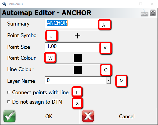
| A |
KEY |
All |
Text |
Point Description (read-only) NOTE: must not contain spaces or hyphens |
| B |
DESC TEXT |
All |
Text |
Plotted Description |
| C |
DESC LAYER |
Map360 |
Layer |
Description label layer |
| D |
SYMBOL |
Map360 |
String |
Symbol Path and Filename |
| E |
SYM SCALE |
Map360 |
Real |
Symbol Scale Factor |
| F |
SYM LAYER |
Map360 |
Layer |
Symbol Layer |
| G |
SYM TRIM |
Map360 |
Real |
Symbol Trim Radius |
| H |
MOVE DESC |
Map360 |
Checkbox |
Description Layer Override |
| I |
MOVE NUM |
Map360 |
Checkbox |
Overrides PointID label layer set in annotation settings 0 = off, 1 = on |
| J |
MOVE ELEV |
Map360 |
Checkbox |
Overrides Elevation label layer set in annotation settings 0 = off, 1 = on |
| K |
MOVE NODE |
Map360 |
Checkbox |
Overrides PointID label layer set in annotation settings 0 = off, 1 = on |
| L |
CONNECT |
All |
Checkbox |
AutoMap Process – Connect Points 0 = off, 1 = on |
| M |
LINE LAYER |
All |
Layer |
ie: LAYERNAME |
| N |
LINE TYPE |
Map360 |
Linetype |
ie: CONTINUOUS |
| O |
COLOR |
Color |
Color (AutoMap360 Color Index) |
|
| P |
2D |
Map360 |
Checkbox |
0 = 3D 1 = 2D |
| Q |
LINES |
Map360 |
Checkbox |
0 = polyline 1 = line |
| R |
PLINE WIDTH |
Map360 |
Real |
|
| S |
LEGAL DESC |
Map360 |
Text |
|
| T |
SYM SCALE TOG |
Map360 |
Checkbox |
0 = no scale 1= scale according to drawing scale factor |
| U |
MARKER TYPE |
EVR |
Image |
Assigns Marker used to display point in FieldGenius (Marker Index) |
| V |
MARKER SIZE |
EVR |
Real |
Assigns Marker Size used to display point in FieldGenius |
| W |
MARKER COLOR |
EVR |
Color |
Assigns Marker Color used to display point in FieldGenius (AutoMap360 Color Index) |
| X |
EXCLUDE FROM DTM |
EVR |
Checkbox |
If set to 1 excludes point from DTM in FieldGenius |
| Y |
POINT NUMBER LAYER |
Map360 |
Layer |
ie: LAYERNAME |
| Z |
ELEVATION LAYER |
Map360 |
Layer |
ie: LAYERNAME |
| AA |
NODE LAYER |
Map360 |
Layer |
ie: LAYERNAME |
| AB |
DESC LAYER COLOR |
Map360 |
Color |
(AutoMap360 Color Index) |
| AC |
NUMBER LAYER COLOR |
Map360 |
Color |
(AutoMap360 Color Index) |
| AD |
ELEV LAYER COLOR |
Map360 |
Color |
(AutoMap360 Color Index) |
| AE |
NODE LAYER COLOR |
Map360 |
Color |
(AutoMap360 Color Index) |
| AF |
SCALE LAST |
Map360 |
Checkbox |
Scale Symbol to Previous Point 0 = off, 1 = on |
| AG |
ROTATE LAST |
Map360 |
Checkbox |
Rotate Symbol to Previous Point 0 = off, 1 = on |
| AH |
ROTATE RANDOM |
Map360 |
Checkbox |
Rotate Symbol Randomly 0 = off, 1 = on |
| AI | NO SYM ROTATION |
Map360 |
Checkbox |
Do not Rotate Symbol 0 = off, 1 = on |
| AJ |
PLOT EXACT DESC |
Map360 |
Checkbox |
Plot Description exactly as defined in the field 0 = off, 1 = on |
| AK |
DESC_X_OFF |
Map360 |
Real |
Description Label, X Offset |
| AL |
DESC_Y_OFF |
Map360 |
Real |
Description Label, Y Offset |
| AM |
POINTID_X_OFF |
Map360 |
Real |
Point ID Label, X Offset |
| AN |
POINTID_Y_OFF |
Map360 |
Real |
Point ID Label, Y Offset |
| AO |
ELEV_X_OFF |
Map360 |
Real |
Elevation Label, X Offset |
| AP |
ELEV_Y_OFF |
Map360 |
Real |
Elevation Label, Y Offset |
| AQ |
POINTID_MODIFIER |
Map360 |
Menu |
0=None,1=Ellipse,2=DoubleEllipse,3=Rectangle |

James Johnston
Comments